
|
||
|
|
||
|
||
|
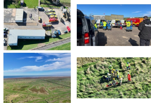
How we use our drones - multi-agency exercise - plane crash |
||
|
Find out what can our drones offer at the scene of a major incident.
Earlier this week, along with colleagues from the Royal Air Force, East Midlands Ambulance Service, Lincolnshire Fire and Rescue and HM Coastguard, we tested our emergency response plans during an exercise involving a simulated plane crash.
Our birds eye view from the sky offers commanders an immediate view of any crash site or major incident. Helping to assess the size of the incident, where debris has spread, where fire may have spread and the location of survivors or casualties. This is especially useful over difficult terrain. The drone has thermal imaging and can capture body heat so can see more than the naked eye. The thermal imaging can also pick up the spread of burning embers which allows fire officers to track the spread of a fire.
Drones can capture high resolution images and create 3D maps or orthomosiac maps for investigators who will be tasked with finding out what has happened when the immediacy of the incident has passed.
We can share our live drone footage with multiple agencies who can use the views to ensure dangerous areas are assessed without sending staff into unsafe environments.
These are just a few benefits of how our Drone team assist in policing. Every day they are involved in finding missing people, helping to search large areas or track suspects who are fleeing; these are just a few examples. Our drones are an integral part of keeping our communities in our lovely county of Lincolnshire safe.
Our Drone team have started to publish more of their work on a newly created Facebook page. If this is something that would be of interest you can find them on Facebook at Lincolnshire Police Drone Team.
We've shared some images taken from our drone of the multi-agency exercise. We hope you find this insight helpful.
| ||
Reply to this message | ||
|


|